UPDATE: Robertson Draw Fire Growth Slows; Some Evacuations Lifted
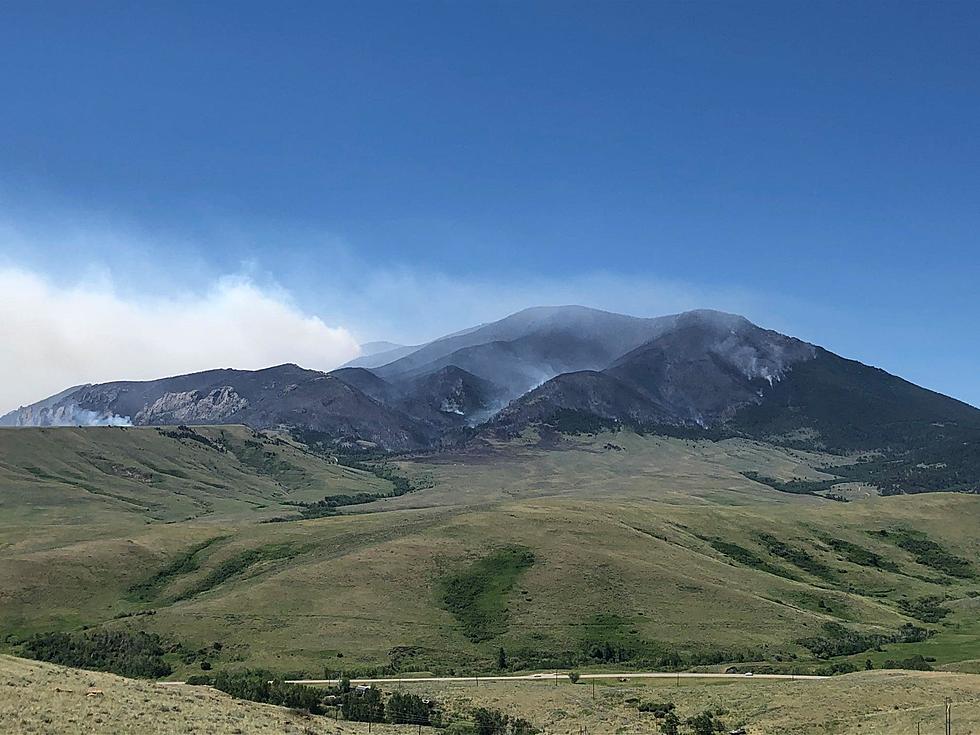
At 8:00 a.m. on Friday, June 18, the Custer Gallatin National Forest provided an update, providing facts about the Robertson Draw Fire burning 7 miles south of Red Lodge, Montana. The fire is currently the largest in the state.
The good news is that there has been little growth in the past 24 hours. As of June 17, The Robertson Draw Fire was estimated at 24,273 acres. As of today, June 18, the fire is estimated at 24,470 acres. There are currently 214 firefighters working to extinguish the wildfire.
On Thursday, Montana Governor Greg Gianforte visited with Incident Command and local officials in Belfry and received a briefing on the Robertson Draw Fire by Operations personnel.

Current Status of the Robertson Draw Fire
On Thursday, June 17, firefighters made good progress on several areas of the fire. On the southeast, eastern, and northeast sides of the fire crews continued to mop up along the fire’s edge and worked with residents as they reentered their properties. Firefighters walked the fire’s edge on the eastern and northeastern sides looking for any pockets of heat and extinguishing them when found. On the south side, firefighters tied the indirect line into an old fire scar and worked on indirect line construction. On the north side, fire crews continued to work on securing the fire perimeter south of Bear Creek. On the northwest and west sides firefighters scouted for possible indirect line locations that will provide opportunities for success in fire suppression. Air tankers and Helicopters continued to make numerous water, retardant, and bucket drops. Night shift operations with five engines patrolled the eastern areas of the fire mopping up as needed near structures. A majority of fire activity yesterday was in the upper reaches of the Grove Creek and Line Creek drainages where it was actively burning in mid-slope timber with short upslope runs, group torching, and spotting.
Planned Actions for Friday, June 18
On the south side, fire crews will continue to work on indirect line and utilize aircraft as necessary. On the eastern and northeastern sides of the fire crews will continue to patrol and mop up any areas of heat or smoke along the fire line. On the northwest side, firefighters will continue to plan indirect line and begin to start some of that work. The structure protection group will continue to assess structures and develop a structure protection plan that includes flagging access roads and numbering structures. On the west side of the fire, the crew will be scouting for opportunities to work on an indirect or direct fire line based on the fire activity at the head of the Line Creek drainage.
UPDATE on Evacuations
Evacuation Orders have been lifted as of 6:00 PM on June 17, 2021, for the areas of North and South Grove Creek, Gold Creek, Ruby Creek, and Robertson Draw east to Highway 72. These areas will remain in evacuation warning status, but residents can return to their homes. All area residents are recommended to have a household evacuation plan ready. Please remain vigilant and be aware of the situation and your surroundings. The North and South Grove Creek Road, Gold Creek Road, Ruby Creek Road, Meeteetse Trail, and Robertson Draw Road that are in Evacuation Warning status remain closed to general public use.
UPDATE on Closures
All the Custer Gallatin National Forest System lands south of Point of Rocks in the Rock Creek drainage is closed under a Forest Closure Order. This includes trailheads, campgrounds, dispersed camping areas, and the USDA Forest Service Recreation Residences in Corral Creek, Spring Creek, Snow Creek, and Sheep Creek. The areas within the Forest Closure Order remain in evacuation and include the USDA Forest Service Recreation Residences in Corral Creek, Spring Creek, Snow Creek, and Sheep Creek. This is in addition to the Closure Area encompassing the Line Creek Plateau. The Beartooth Highway (US Hwy 212) remains open. In addition, there is a Closure Order on all Bureau of Land Management lands lying West of State Highway 72, South of State Highway 308, and East of US Highway 212 in Carbon County. The Robertson Draw Fire will be utilizing Cooney Reservoir north of Red Lodge for scoop plane activities to assist firefighting efforts. People will not be able to be in the water while these air operations are ongoing. If you wanted to get on the water at Cooney Reservoir today, please make different plans.
Temporary Flight Restrictions (TFR)
The current TFR in place for air space over the Robertson Draw Fire (FDC 1/3808) will lessen impacts to local aviation operators. Remember that temporary flight restrictions also apply to unmanned aircraft systems (UAS) or drones.
Why do cats have whiskers? Why do they meow? Why do they nap so much? And answers to 47 other kitty questions:
Gallery Credit: Andrew Lisa
Five Must-See Montana Travel Destinations For 2021
More From My 103.5 FM